|
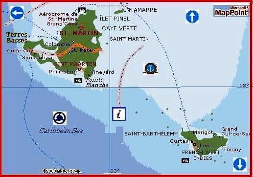
SAINT-MARTIN,
hol.
Sint Maarten,
wyspa w Ameryce Środk.,
w Indiach Zach., w archipelagu Małe Antyle (Wyspy Podwietrzne); pn. część wyspy
(pow. 52 km2, 29 tys. mieszk. 1990, gł. m. Marigot) należy do
Gwadelupy (departament zamor. Francji); rybołówstwo; uprawa trzciny cukrowej,
bawełny; hodowla koni; pd. część wyspy (pow. 34 km2, 33 tys. mieszk.
1992, gł. m. Philipsburg) wchodzi w skład Antyli Holenderskich; wydobycie soli
kam. z wody mor.; uprawa batatów; produkcja rumu; rybołówstwo; turystyka.
ANTYLE HOLENDERSKIE, De
Nederlandse Antillen,
terytorium autonomiczne Holandii w Ameryce Środk., w Indiach Zach., na Małych
Antylach; obejmuje wyspy Curaçao (pow. 444 km2) i Bonaire (288 km2)
w pd.-wsch. części M. Karaibskiego, u wybrzeży Wenezueli oraz wyspy Saba (13 km2),
Sint Eustatius (21 km2) i część wyspy Saint-Martin (Sint Maarten, 34
km2) w pn.-wsch. części M. Karaibskiego, na wsch. od Puerto Rico;
pow. 800 km2, 195 tys. mieszk. (1996), gł. Murzyni i Mulaci; stol.
Willemstad (na wyspie Curaçao); język urzędowy — hol.; jednostka monetarna —
floren Antyli Holenderskich.
Curaçao i Bonaire są wyspami
pochodzenia kontynent., zbud. gł. z silnie skrasowiałych wapieni; Saba, Sint
Eustatius i Saint-Martin są pochodzenia wulk. (na wyspie Saba wys. do 880 m);
wszystkie wyspy otaczają rafy koralowe; klimat podrównikowy, na wyspach, na
wsch. od Puerto Rico, wilgotny (z częstymi cyklonami), na wyspach w pobliżu
wybrzeży Wenezueli — suchy; roślinność na Curaçao i Bonaire kserofilna, na
pozostałych wyspach gł. wilgotniejsze odmiany sawann.
Podstawą gospodarki Antyli
Holenderskich jest przetwórstwo i eksport ropy naft. (sprowadzanej gł.
z Wenezueli) oraz usługi finansowe; Antyle Holenderskie są jednym z najbardziej
rozwiniętych krajów w basenie M. Karaibskiego, dochód nar. 6110 dol. USA na 1
mieszk. (1985); rafineria ropy naft. (Curaçao), przemysł chem., elektrotechn.,
spoż.; wydobycie fosforytów (Curaçao), soli kam. (Bonaire, Curaçao); uprawy
agawy sizalskiej, drzew cytrusowych (zwł. pomarańczy gorzkiej, z której wyrabia
się słynny likier), roślin garbnikodajnych, aloesu; hodowla gł. kóz i owiec;
rybołówstwo; rozwinięta turystyka (wyspy: Curaçao, Saint-Martin); eksport
produktów naft. (97% wartości eksportu — 1984), chem. i elektrotechn.; handel
gł. z Wenezuelą (34%) i USA (29%).
Ustrój polityczny.
Terytorium autonomiczne Królestwa Holandii; ustrój określa Karta Królestwa
Holandii z 1954; monarchę hol. reprezentuje mianowany przezeń gubernator, który
powołuje Radę Ministrów i działa we współpracy z nią; za politykę zagr. i obronę
jest odpowiedzialny rząd hol.; władza ustawodawcza (w sprawach wewn.) należy do
1-izbowego parlamentu (Stany Antyli Holenderskich), wybieranego w wyborach
powszechnych i bezpośrednich na 4 lata; władzę wykonawczą sprawuje
odpowiedzialna przed parlamentem Rada Ministrów, z premierem na czele.
Historia.
Antyle Holenderskie zostały odkryte przez K. Kolumba (Antyle — Historia); w 1.
poł. XVII w. teren rywalizacji Hiszpanii, W. Brytanii i Holandii; 1634 hol.
Kompania Zachodnioindyjska zdobyła wyspy: Curaçao, Arubę i Bonaire, 1636
przyłączyła Sint Eustatius i Sabę, 1648 zajęła, wraz z Francją, Sint Maarten
(Saint-Martin); po rozwiązaniu Kompanii — kolonia hol.; w XVII i XVIII w. duże
znaczenie w handlu mor. — centrum handlu i redystrybucji niewolników z Afryki;
po jego likwidacji w XIX w. przejściowy upadek ekon.; od 1954 autonomia; 1986
Aruba wystąpiła z federacji Antyli Holenderskich i uzyskała odrębną autonomię.
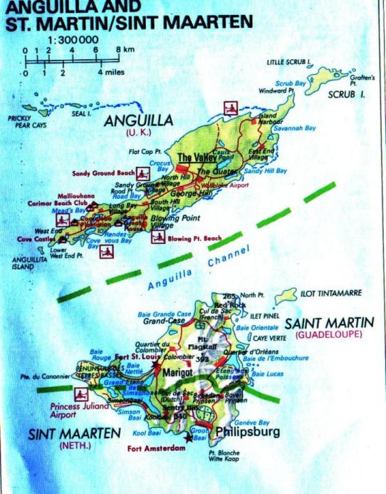
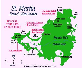
Dutch Sint Maarten, French Saint-martin
island at the northern end of the Windward group of the Lesser Antilles in the
Caribbean Sea. The island is hilly and receives about 45 inches (1,140 mm) of
rain annually. The southern third is controlled by the Dutch, the northern
two-thirds by the French.
The island was named by Christopher Columbus in honour of the saint on
whose feast day the island was discovered. Valued for its natural lakes of salt,
a scarce commodity in Europe, it changed between Dutch and Spanish hands several
times. In 1648 the Dutch returned to the island to find it occupied by the
French, with whom they signed a partition treaty. Sugarcane plantations, worked
by black slaves (ancestors of most of the present inhabitants), were important
for a time but declined in the 19th century.
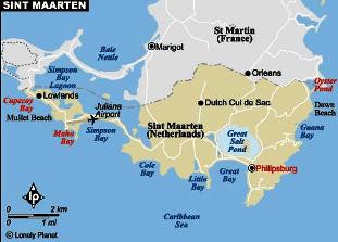
The Dutch (southern) part of the island, Sint Maarten, covers 13 square miles
(34 square km) and has coastal lagoons, salt pans, and sandspits. It became a
part of the Dutch West Indies in 1828, and in 1845 it became one of the original
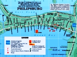
six (now five) islands of the Netherlands Antilles. The capital is Philipsburg.
The economy draws increasingly on tourism as the government encourages
exploitation of the island's most valuable natural resources, the clean beaches
and pleasant climate.
The French (northern) part of the island, with an area of 20 square miles (52
square km), has beaches and forest-covered hills. It is one of seven islands
forming the French overseas département of Guadeloupe. Fishing is the
main occupation on Saint Martin, but tourism is developing
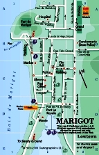
rapidly. Trade flourishes in Marigot, the capital. Most of the people are
English-speaking blacks. Pop. (1994 est.) Dutch Sint Maarten, 35,839; (1990)
French Saint-Martin, 28,518.
Netherlands Antilles
The people.
The racially mixed population of the Netherlands Antilles includes strains of
European, African, and American Indian stock. The predominantly black northern
group reflects the cultural influence of its British-related neighbours, while
the southern islands, with stronger ties to Venezuela and Colombia, show a more
marked Latin influence. Whites form small minorities on all of the islands
except Saba, where there is about an even division between black and white.
Curaçao has about three-fourths of the total population, most of whom live in
Willemstad,
the Netherlands Antilles' largest city. The next most populous island is the
Dutch part of Saint Martin.
Papiamento,
a mixture of Spanish, Portuguese, and Dutch, is common in the south, as is
Spanish; English is also spoken, especially in the northern group. Dutch is the
official language, though it is not widely spoken. About three-fourths of the
population is Roman Catholic, and one-tenth of the people are members of various
Protestant denominations. There are also several small Jewish communities, said
to be the oldest continuous Jewish communities in the Americas.
The economy.
The southern islands' proximity to the Venezuelan oil fields, their location on
well-established shipping routes, and their deep natural harbours have made the
refining, storage, and transshipment of oil the mainstay of the economy,
particularly on Curaçao. The government offers many important fiscal and tax
incentives to encourage the development of new industry, especially tourism,
which has become a major business on all five islands and has lessened the
islands' dependence on petroleum refining. The islands' relative political
stability has made the territory attractive to foreign investment, and
Willemstad has become a Caribbean centre for banking and other financial
services. Agriculture, especially in the southern islands, is limited by
insufficient rainfall and thin topsoil.
Aloes
for pharmaceutical products and
oranges
for Curaçao liqueur are grown on Curaçao. Most food must be imported. The only
natural resources on the islands are phosphates and salt, and, with the
exception of oil refining on Curaçao, there are only a few light industries.
Almost all manufactured goods must be imported. Saint Martin has
developed a fishing industry, and there is some livestock raising. Most of the
islands' drinking water is obtained through distillation. The gross national
product (GNP) declined during the 1980s because of the downturn in world demand
for petroleum, Aruba's separation from the Netherlands Antilles, and a static
tourist industry on the islands, but the petroleum and tourist trades improved
somewhat by the mid-1990s. Venezuela, the United States, and The Netherlands are
among the islands' main trading partners.
Transportation is considerably more developed in the economically more important
southern islands. Most of the islands' roads are on Curaçao. All of the islands
have airfields, those on Curaçao, Bonaire, and Saint Martin being
of international class. Interisland air service is also provided. The main port
is Willemstad.
History
Political developments since World War II
After World War II, negotiations began with the aim of conferring a greater
measure of self-government on the islands. On Dec. 15, 1954, a charter was
signed making the islands an autonomous part of The Netherlands. In 1969,
Curaçao was torn by labour conflicts leading to riots and arson. Since then
discussions on complete independence have been held intermittently.
Politics in the Netherlands Antilles are now dominated by three issues: economic
problems, the coming of independence, and the degree of autonomy to be afforded
each island within the federation. By the mid-1970s it was clear that most of
the Netherlands Antilles feared the economic consequences of independence. The
Dutch government pressed for independence but insisted on preserving a federated
structure embracing all islands. In an unofficial referendum in 1977, Aruba
voted to secede from the Antilles federation but remained within the kingdom. By
1978 all the islands had accepted the concept of insular self-determination.
David Russell Harris
Harmannus Hoetink
In 1989 the political leadership of Saint Martin announced its
desire to achieve full independence in the shortest possible term; secessionist
feelings were fueled by animosity toward the central administration in Curaçao.
An investigation by the government of The Netherlands into the administration of
Saint Martin resulted in 1993 in the arrest of two prominent
leaders on charges of corruption and led to closer supervision by the
metropolitan government of the island's affairs.
Efforts to placate secessionist sentiment in the islands by increasing insular
autonomy apparently had the desired results, since during the mid-1990s all five
islands voted to remain within the Netherlands Antilles.
Harmannus Hoetink
The Editors of the Encyclopædia Britannica
The economy
Agriculture
Agriculture plays a minor role in the economy of the islands, although sugarcane
and cotton plantations were once established on Saint Martin and
Sint Eustatius. Curaçao was at one time used mainly for livestock raising, but,
after the overgrazing of land, new small-scale agricultural ventures were begun,
such as the cultivation of aloes for pharmaceutical products and oranges for
Curaçao liqueur. Aloes also are grown on Bonaire. Fish are important to the
economy of Sint Maarten. Saba is engaged chiefly in raising livestock and
cultivating vegetables, particularly potatoes, which are exported to
neighbouring islands.
Industry
The main industry of Curaçao is oil refining, which started with the opening up
of the Venezuelan oil fields in 1914. After the oil refinery opened in 1918 on
Curaçao, the industry became the economic mainstay of the islands. Bonaire has a
textile factory, and Sint Maarten a rum distillery. Willemstad has become an
important Caribbean banking centre. For all of the islands, tourism and service
industries have become increasingly important.
Copyright © 1994-2002 Encyclopædia Britannica, Inc
|