|
Dominika
|
|
 |
 |
 |
 |
|
Wiki - wolna
encyklopedia internetowa (pol.)
Opis:
po angielsku i francusku.
Dokładna
mapa drogowa
(ang.)
Bardzo bogata i
pełna informacji i
zdjęć strona (ang.)
Strona państwa z dużą
ilością przydatnych informacji (ang.)
Strona brytyjska (ang.)
Historia
wyspy (ang.)
Galeria zdjęć
14-tej
Szkoły pod Żaglami.
Przepiękne
panoramiczne
widoki (podróż wirtualna - kliknij na wybraną panoramę)
Dużo ważnych i interesujących
faktów,
zdjęć i mapek (ang.)
Link do
ciekawego opisu i
galerii (ang.)
Galen R.
Frysinger
- galeria
pięknych zdjęć z dużą ilością opisów (ang.)
|
|
|
 |
 |
 |
 |
|
 |
PWN
DOMINIKA,
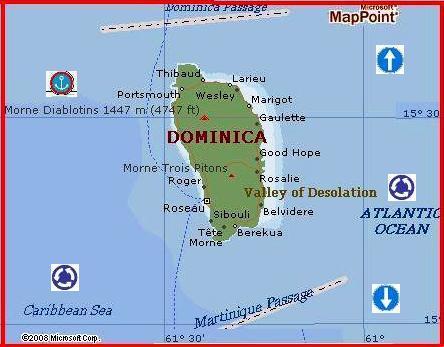
Dominica, Wspólnota Dominiki, Commonwealth of Dominica, państwo w Ameryce
Środk., w Indiach Zach.; na wyspie Dominika na M. Karaibskim, w grupie
W. Zawietrznych (Małe Antyle).
Informacje ogólne
Stolica: Roseau
Powierzchnia: 751 km2
Ludność: 74 tys. mieszk.
(1996)
Język urzędowy: angielski
Jednostka monetarna: dolar
wschodniokaraibski
Święto narodowe: 3
listopada (rocznica uzyskania niepodległości 1978)
Podział administracyjny: 10
parafii
|
|
Dominica
Largely rural,
uncrowded and unspoiled, Dominica touts itself as a 'non-tourist destination'
for divers, hikers and naturalists - partly because it lacks those white-sand
beaches so favored by holidaymakers to the Caribbean. The island's main
attractions involve strapping on some gear and working up a sweat, making
it a great destination if your interests extend beyond lying motionless in the
sun.
Dubbed the
Caribbean's 'Nature Island,' Dominica has a lush mountainous interior of
rainforests, waterfalls, lakes, hot springs and more than 200 rivers, many of
which cascade over steep cliff faces en route to the coast. The only way to
really experience this fabulous terrain is to pull on your hiking boots and
start walking. Get ready to test your calf muscles because the island has the
highest mountains in the Eastern Caribbean; the loftiest peak, Morne Diablotin,
is 4747 feet (1447 m) high - not bad for an island measuring only 29 miles
(47km) by 16 miles (26km).
Apart from its
natural splendours, the island has an interesting fusion of British, French and
West Indian cultural traditions, and is home to the Eastern Caribbean's largest
Carib Indian community.
Area:
290 sq miles (166 sq km)
Population: 71,540
Capital city: Roseau
People: African descent (90%), native Carib (4%)
Language: English, French-based patois
Religion: Roman Catholic 77%, Methodist 5%, Pentecostal 3%, Baptist 2%,
Seventh Day Adventist 2%, and other 7%, none 4%
Government: Independent state within the British Commonwealth
Prime Minister: Roosevelt Douglas
GDP:
US$225 million
GDP per head: US$3400
Annual growth: 2%
Inflation: 1.1%
Major industries: Agriculture (primarily bananas and coconuts), tourism,
shoes, furniture, cement blocks
Major trading partners: Caricom countries, Italy, USA, UK, Japan, Canada
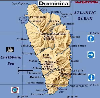
Orientation
Most of Dominica's attractions and
places to stay are along the west coast or in the mountains just inland from the
capital, Roseau.
Dominica has two airports: Canefield,
a 10-minute drive from Roseau, and Melville Hall, on the secluded northeast side
of the island. If you're planning to base yourself in Roseau, try to avoid
Melville Hall as it's a good 75-minute haul to the capital.
This is a large island, but the
primary roads are well paved and getting around is easy. With a reasonably early
start, it's possible to drive up the west coast from Roseau to Portsmouth,
explore Cabrits National Park, travel down the east coast through the Carib
Territory and stop at the Emerald Pool on your way back across the island, all
in a full-day outing.
Facts for the
Traveler
Visas:
Most visitors to Dominica must have a valid passport, but US and Canadian
citizens can enter with just proof of citizenship, such as a photo ID and an
official birth certificate. French nationals may visit for up to two weeks with
a Carte d'Indentité. Only citizens of former Eastern Bloc countries
require visas. A roundtrip or onward ticket is officially required of all
visitors.
Health risks: Sunburn, diarrhea and intestinal parasites; leptospirosis
can be present in freshwater streams.
Time: GMT/UTC minus four hours
Electricity: 220/240V, 50 Hz
Weights & measures: Imperial
Telephoning: From North America, dial 1 + 767 + the seven-digit local
number. From elsewhere, dial your country's international direct dialing prefix
+ 1 + 767 + the seven-digit local number.
History
The Caribs, who settled here in the
14th century, called the island Waitikubuli, which means 'tall is her body.'
With less poetic flair, Christopher Columbus named the island after the day of
the week he spotted it - Sunday, 3 November 1493.
In 1607, Captain John Smith and his
followers stopped at the Dominican coastal settlement of Portsmouth for a couple
of days before heading north to establish Jamestown, North America's first
permanent English settlement. The harbor became so important to the British that
they intended to make Portsmouth the island's capital until outbreaks of malaria
and yellow fever thwarted the plan.
France laid claim to the island in
1635 and a few years later sent a contingent of missionaries, who were driven
off by unwelcoming Caribs. The French and English signed a neutrality treaty in
1660 agreeing to Carib possession of the island. Nevertheless, French settlers
from the neighboring French West Indies began establishing coffee plantations on
Dominica toward the end of the century. France then sent a governor in the 1720s
and took formal possession of the island.
For the remainder of the 18th
century, Dominica was caught up in the French and British skirmishes that marked
the era, changing hands between the two powers several times. Under the Treaty
of Paris, the French reluctantly ceded the island to the British in 1763. The
French tried to recapture Dominica in 1795 and again in 1805, when they managed
to burn much of Roseau to the ground.
After 1805 the island remained
firmly in the possession of the British, who established sugar plantations on
Dominica's more accessible slopes. The British administered the island as part
of the Leeward Islands Federation until 1939, when it was transferred to the
Windward Islands Federation. In 1967, Dominica gained control over its internal
affairs as a West Indies Associated State; in 1978, on the 485th anniversary of
Columbus' 'discovery,' Dominica became an independent republic within the
Commonwealth.
The initial year of independence was
a turbulent one. The island's first prime minister, Patrick John, was forced to
resign in June 1979 after a series of corrupt schemes came to light, including
an attempt to transfer 15% of the island to US developers. Hurricane David,
packing winds of 150 miles an hour, devastated the island in August 1979,
denuding vast tracts of forest, destroying banana crops and wreaking havoc on
much of Roseau. 42 people were killed and 75% of the islanders' homes were
destroyed or severely damaged.
In 1980 Mary Eugenia Charles was
elected Prime Minister, becoming the first female elected head of state in the
Caribbean. Within a year of her inauguration she survived two unsuccessful
coups, including a bizarre attempt orchestrated by Patrick John involving
mercenaries recruited from the Ku Klux Klan.
As chairperson of the Organization
of East Caribbean States, Prime Minister Charles endorsed the 1983 US invasion
of Grenada and sent a symbolic force of Dominican troops to participate. An
appreciative USA responded with increased aid to Dominica, one consequence of
which is the island's fine paved roads. After 15 years in office, Charles
resigned in 1995 and was replaced by Edison James of the United Workers' Party (DUWP).
The most recent elections were held
in January of 2000. Roosevelt Douglas, leader of the Labour Party of Dominica
(LDP), became the new prime minister.
Culture
Despite Dominica's political
affiliations and choice of measurement standard, the French have had a more
lasting influence on the island than the British. This can be seen in the
predominance of Roman Catholicism, the widespread use of French-based patois,
and the commonness of French place names. African, West Indian and native Carib
traditions all contribute to a Creole culture, resulting in mix of language,
food, art and customs. Common sights include Carib dugout canoes, stilt houses,
Rastafarian dreadlocks, and red, green and yellow African clothing. Dominica has
a thriving music scene, centered mainly around reggae, calypso and zouk. Cricket
and soccer are the most popular sports.
Dominica's most celebrated author,
Jean Rhys, was born in Roseau in 1890. Although she moved to England at age 16
and only made one brief return visit to Dominica, much of her work draws upon
her childhood experiences in the West Indies. Rhys touches lightly upon her life
in Dominica in her books Voyage in the Dark (1934) and her autobiography
Smile Please (1979).
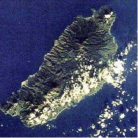
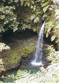
Environment
Dominica is 500 miles (805 km)
northeast of Caracas, Venezuela, and 375 miles (605 km) southeast of San Juan,
Puerto Rico. Its nearest neighbors are Guadeloupe (60 mi/95 km north) and
Martinique (55mi/90 km south). Slightly larger than Guam and shaped a bit like a
bottle of port, Dominica is 29 miles (47km) long and 16 miles (26km) wide. It
has the highest mountains in the Eastern Caribbean; the loftiest peak, Morne
Diablotin, is 4750ft (1450m) high. The mountains, which act as a magnet for
rain, serve as a water source for the more than 200 rivers that run down the
mountain valleys. En route to the coast many of the rivers cascade over steep
cliff faces, giving the island an abundance of waterfalls.
More than 160 bird species have been
sighted on Dominica, giving it some of the most diverse bird life in the Eastern
Caribbean. Of these, 59 species nest on the island, including two endemic and
endangered parrot species. Dominica's national bird, the Sisserou, also called
the Imperial Parrot, is about 20in (50cm) long when full grown, the largest of
all Amazon parrots. Other critters include large crapaud frogs, lizards, 13
species of bat, 55 of butterfly, boa constrictors that grow nearly 10ft (3m) in
length and four other types of snakes (none poisonous).
Dominica is well known for its vast
rainforests, but the island also has montane thickets, dry scrub woodlands,
evergreen forests, fumarole vegetation, cloud forests and elfin woodlands. The
most abundant tree on the island is the gommier, a huge gum tree that's
traditionally been used to make dugout canoes. The most colorful of Dominica's
endemic plants is its national flower, the bwa kwaib, or Carib tree. A deciduous
shrub, it's found on the island's drier west coast. In spring, the bare branches
of this shrub suddenly become thick with hundreds of scarlet flowers, adding a
bright splash to the countryside.
In January the average high
temperature is 85°F (29°C) while the low averages 68°F (20°C). In July the
average high is 90°F (32°C) while the low averages 72°F (22°C). The driest
months are February to June. All these statistics are for Roseau - the mountains
are cooler and wetter.
Attractions
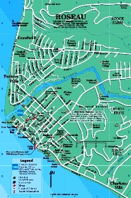
Roseau
While Roseau (pronounced 'rose-oh')
is one of the region's poorer capitals, it's not the grimmest. Shopkeepers wash
down the sidewalks every morning, the streets are lined with old stone-and-wood
buildings, and mountains form a verdant backdrop. The city has rebuilt its
waterfront, which was severely damaged by Hurricane David, and it now boasts a
new cruise ship dock and promenade. There are a growing number of modern cement
structures too, since this is a functional market town, but for the most part
walking Roseau's quieter backstreets feels like stepping back a hundred years in
time.
You can get a reminder of the more
inhumane aspects of Dominica's colonial past in the cobblestone plaza of the Old
Market, the site of a former slave market, where a wrought iron Victorian-style
memorial marks the old block where slave auctions took place. There are
interesting displays on the slave trade, Creole and Amerindian culture at the
Dominica Museum. At the public market you can find fresh fruit, vegetables and
herbs; the blowing of a conch shell signals fresh fish for sale. Other
worthwhile sights include the old stone Catholic cathedral, the botanical
gardens, the Anglican church, and the public library, built in 1905 with funds
from US philanthropist Andrew Carnegie.
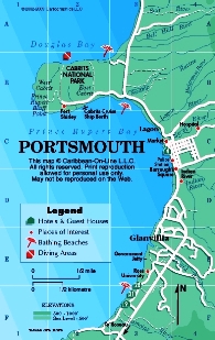
Cabrits National
Park
Located on a scenic peninsula just
north of Portsmouth, this park is best known as the site of Fort Shirley, a
large 18th-century British garrison which once housed 600 soldiers. Some of the
fort's stone ruins have been partially reconstructed; others are half-hidden in
the jungle and are fun to explore. There are fine views of Prince Rupert Bay
from the ruins of the Officer's Quarters. The park encompasses the peninsula,
the surrounding coast and coral reefs, and the island's largest swamp.
Carib Territory
The 3700-acre (1497-hectare) Carib
Territory is home to most of Dominica's 3000 Carib Indians. After exposure to
European-borne diseases in the 17th century, the Carib population here fell to
just a few hundred, but that was fortunate compared to the decimation Caribs
suffered on other Caribbean islands. The remaining few were removed to a small
'reserve' in the mid-18th century - the nucleus of the present-day Territory.
Although their numbers have increased since then, their culture has been eroded
by Roman Catholicism and the English and French Creole languages.
The Territory is a predominantly
rural area with banana and breadfruit trees and wild heliconia growing along the
roadside. Many of the houses are traditional Carib-style wooden structures on
log stilts, but the poorer areas consist of shanties made of corrugated tin and
tarpaper. Salybia is the main settlement, while the L'Escalier Tête Chien at
Sineka is the most popular attraction. This unique stairway-like lava outcrop
appears to climb out of the turbulent ocean and was thought by the Caribs to be
the embodiment of a boa constrictor; it holds a significant place in many Carib
legends.
Layou River Area
The Layou River, Dominica's longest,
empties into the sea just south of St Joseph, at the center of the west coast.
The river basin is a peaceful rural area, with bamboo leaning over the river
banks and banana and coconut trees at the side of the road. When it's not
running strong, the river is a popular place for freshwater swimming.
St Joseph, a simple fishing village
of 2600 people, rises up the slope from a small black-sand beach, but the area's
best beach is farther north at the Castaways Beach Hotel in Mero. There's good
swimming in front of Castaways and fair snorkeling along the rock formations at
the southern end of its beach -- with a little luck you might even spot a sting
ray or octopus.
Portsmouth
Portsmouth, Dominica's
second-largest town, sits on the banks of Prince Rupert Bay. Columbus entered
the bay during his fourth voyage to the New World in 1504.
Although Portsmouth center doesn't
have any sights per se, there are a couple of oddities you might want to take a
look at: the small but colorful monument at the bus stop dedicated to Lord
Cathcart 'who died of the bloody flux off Dominica in 1741' and the nearby line
of shipwrecks piled up in the shallow waters at the back of the police station.
|
|
|
Dominique qui
se prononce «Dom-in-eek-a » est une île de formation volcanique qui se situe
entre les îles françaises de la Guadeloupe et la Martinique dans les petites
Antilles, approximativement à 15 degrés Nord et 61 degrés Ouest. C'est la plus
montagneuse des îles sous le vent, longue de 40 km et large de 20 dans ses plus
grande dimensions. Le nom de « Commonwealth of Dominica » est souvent utilisé
pour la distinguer de la République Dominicaine (à ce propos, le Zip code
00109-8000 assure que le mail n'est pas une erreur d'envoi en République
Dominicaine).
Il y a plusieurs sommets à plus de
1000m, les plus hauts sont le Morne Diablotin 1447m et le Morne Trois Pitons
1402m.
L'île de la
Dominique est connue pour ses forêts tropicales, et ses innombrables rivières et
cascades qui sont le résultat des pluies intérieures intenses.
De plus ses origines volcaniques se manifestent partout et plus intensément
encore au
Lac Bouillant
(un des plus grand dans le monde) et de nombreuses fumeroles dont certaines sous-marines.
L'île est également réputée pour ses sites de plongée et constitue le meilleur
lieu pour aller observer les baleines dans la région (voir dans le monde.
|
 |
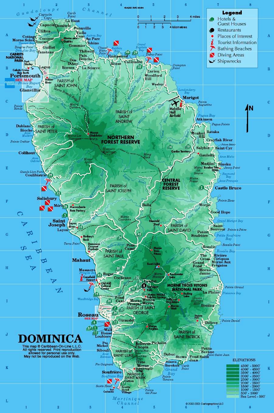
Voici la présentation de quelques-uns des nombreux Parcs Nationaux et
réserves sur l'île. Les 17000 acres du Parc National du Morne Trois
Pitons contiennent sans doute la majorité des ressources souterraines
d'eau de la Dominique, des sites fameux, plusieurs lacs de cratère et
cascades, dont la Piscine d'Emeraude, à 14 miles de Roseau.
La
Réserve de Forêt du nord est un bon exemple de la forêt tropicale océanique,
elle est également célèbre en tant que refuge de l'oiseau emblématique national,
le Perroquet Sisserou endémique à l'île mais rare. |
|
Le Parc National Cabrits, situé sur un cap juste au nord de
Portsmouth, abrite le Fort Shirley en partie restauré, ses eaux constituent une
réserve marine.
A l'extrémité Sud Ouest de
l'île, les environs de Scott's Head/Soufrière devraient bientôt être
également une réserve marine.
La population de la Dominique est
à peu près de 71000 habitants, dont 20000 habitent aux environs de la capitale,
Roseau, qui se situe sur la côte au sud Ouest. Roseau tient son nom de la
période française en raison des plantes du même nom qui poussent le long de la
rivière.
La deuxième plus grande ville est
Portsmouth dans le nord ouest, les autres 'urbanisations' se situent dans
le nord est à Marigot et dans le sud à Grand Bay.
L'anglais est la langue officielle
mais
le créole
basé sur le français est très usité dès que l'on s'écarte de la ville et
particulièrement dans les villages. C'est le reflet d'une histoire turbulente
entre les Anglais et les Français qui tour à tour voulait contrôler la
Dominique. Jusqu'à présent les autochtones,
les Caraïbes,
essayaient de coexister. En 1903 ils leur ont été assignés 3700 acres de
Territoire dans le nord-est et sont au nombre de 3000 environ aujourd'hui.
Le nom Caraïbe original de la
Dominique est Waitikubuli, et de nombreux villages ont gardé (ou
connaissent) leur nom en langue Caraïbe.
La devise est le Dollar Caraïbe
(Eastern Caraibean $ qui est indexé au dollar pour 2,7169) Les horaires
d'ouverture des banques sont du Lundi au Vendredi de 8h à 15h (vendredi jusqu'à
17 heures).
La saison de
pêche en eau douce et de chasse est fermée du 1ier mars au 31 août,
elle concerne l'Agouti, les Crabes, les Ecrevisses, le crapaud (Mountain
Chicken) .
Récemment: en raison du déclin de certaines espèces mentionnées ci-dessus,
la saison close a été étendue à toute l'année.
Une autre réglementation que doit avoir en tête un visiteur est que
l'importation et l'exportation de fruit, légumes et fleurs sont restreints; vous
devrez obtenir une licence pour amener des fleurs, par exemple. L'achat de
coraux et coquillages est prohibé.
|
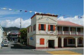 |
Le Museum de Roseau,
est compact mais bien organisé. A l'opposé de la jetée pour les bateaux
de croisière le musée est logé dans l'ancien bâtiment de la poste.
Derrière c'est le Vieux Marché, ancien marché d'esclave où l'on
peut trouver un marché de l'artisanat maintenant. |
|
Le Nouveau Marché,
à l'autre bout du front de mer (Bay Front), est animé le samedi matin très tôt (il
est également ouvert les autres jours de la semaine) avec une grande variété de
fruits, légumes, fleurs tropicales, et produits secs. Vous pourrez toujours y
trouver alentour pour vous désaltérer de l'eau de noix de coco fraîchement coupé.
Le bus écrasé
dans le Jardin Botanique est un témoignage silencieux de la force des
vents de l'Ouragan David (1979), mais également une démonstration de la
puissance régénératrice de la nature (l'arbre tombée sur le bus pousse toujours).
Regardez alentour vous trouverez la maison de bambou, et toute proche une petite
volière avec quelques exemples des rares perroquets Dominicais.
|
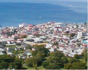 |
Bien
au dessus de la volière il y a un beau point de vue, Morne Bruce,
qui peut être rejoint par le chemin près de l'entrée Est du Jardin, vous
aurez de là une splendide vue de Roseau. |
|
Roseau depuis Morne Bruce
En quittant le Jardin par la porte ouest, allez tout droit et vous passerez
devant Tropicrafts (jetez un coup d'il sur les tapis fait à la main) et regardez
la cathédrale catholique de type Romane sur votre gauche.
Autour du nord
La deuxième
ville de la Dominique est Portsmouth, situé dans le nord-ouest de l'île sur la
Prince Rupert Bay.
|
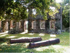 |
Pour
les visiteurs, le point d'attraction du regard sont les Cabrits,
un bras de terre où l'on peut trouver les ruines du Fort Shirley
en partie restauré récemment. Promenez vous autour et vous tomberez sans
doute sur un vieux bâtiment et des canons du fort. |
|
Il
faut voir également près de Portsmouth, la Rivière Indienne, où vous
trouverez des bateaux qui remontent le long de la mangrove sur un mile.
On trouve aussi à
Portsmouth l'université médicale de Ross.
Autour du sud
Sur votre chemin vers le sud de l'île, à peu près un mile après
le village de pêcheur de Pointe Michel, là où la route quitte la côte pour
s'enfoncer vers les montagnes, il y a un chemin qui descend sur une plage de
galets.
A la fin de la plage et à partir de quelques mètres du bord de
l'eau c'est Champagne (appelé aussi Pointe Guignard, Anse Bateaux). Une
aire où l'activité volcanique crée des milliers de bulles qui sortent de la
roche et rejoignent la surface de l'eau.
A l'extrémité de
l'île, les villages de Soufrières et de Scott's Head sont tous deux
magnifiques, Scott's Head se trouve au bout d'un isthme et offre une vue
formidable de la baie, de la côte jusqu'au Nord de l'île, et vers le sud de la
Martinique si le temps est dégagé. Sur la Pointe les ruines de Fort Cachacou
qui était un poste de défense important impliqué dans les actions entre anglais
et français entre 1778 et 1805.
|
 |
Comme son
nom l'implique, Soufrière abrite quelques sources
d'eau chaude riche en soufre.
A noter
une vue inoubliable sur la baie au village de Galion au dessus de
Soufrière. |
|