|
Encyclopedia Brytanica
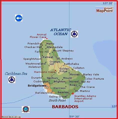
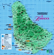
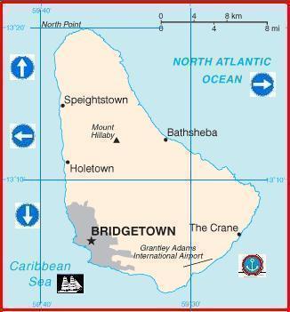
independent island nation in the West Indies, the most easterly of the Caribbean
Islands. It is situated about 100 miles (160 km) east of the Windward Islands
and about 270 miles (430 km) northeast of Venezuela, and covers an area of 166
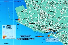
square miles (430 square km). The capital is Bridgetown, the only seaport.
Triangular in shape, Barbados extends at its maximum about 21 miles (34 km) from
northwest to southeast and about 14 miles (23 km) from east to west. The
population in 1990 was estimated at 255,000.
For information about regional aspects of Barbados, see
West Indies: Barbados.
island nation in the Caribbean, situated about 100 miles (160
kilometres) east of the Windward Islands. Roughly triangular in shape, it
measures 21 miles from northwest to southeast and about 14 miles from east to
west, with a total area of 166 square miles (430 square kilometres). Its capital
is Bridgetown, the only seaport.
Barbados is not part of the Lesser Antilles, although it is
sometimes grouped with this archipelago. The island is of different geologic
formation; it is less mountainous and has less variety in plant and animal life.
The geographic position of Barbados has profoundly influenced the island's
history, culture, and aspects of its economic life. In the era of sailing ships,
access to the island was difficult because of the prevailing winds from the
northeast. Outward-bound ships from Europe had to gain the island while heading
west, for it was difficult for them to turn and reach its shores by sailing
eastward against the wind.
The
island remained a British possession without interruption from its settlement in
the 17th century to 1966, when it attained independence. As the first Caribbean
landfall from Europe, Barbados has functioned since the late 17th century as a
major link between western Europe (mainly Britain), eastern Caribbean
territories, and parts of the South American mainland. Because of its long
association with Britain, the culture of Barbados is probably more British than
that of any other Caribbean island. Since independence, however, cultural
nationalism and regional awareness have tended to increase.
Physical and human geography
The economy
Finance and trade
Barbados' banking system consists of commercial banks (mostly branches of
international banks), a central bank, and various development-oriented financial
institutions. A small securities exchange, trading in the stock of locally owned
companies, has operated since 1987. During the 1980s there was considerable
growth in the offshore financial sector.
The chief exports include electrical components, processed foods, clothing,
furniture, and chemicals. Principal imports include food products, machinery,
and fuels. Barbados' main trading partners are the United States, the United
Kingdom, and Trinidad and Tobago and other members of Caricom (Caribbean
Community and Common Market).
Transportation
The island has a network of good roads. Bridgetown has a deepwater harbour, and
several international airlines and British West Indian Airways offer regular
services to Grantley Adams International Airport near the southern coast.
The rocks underlying Barbados consist of sedimentary deposits,
including thick shales, clays, sands, and conglomerates, laid down approximately
70 million years ago. Above these rocks are chalky deposits, which were capped
with coral before the island rose to the surface. A layer of coral up to 300
feet (90 metres) thick covers the island, except in the northeast physiographic
region known as the Scotland District, covering 15 percent of the area, where
erosion has removed the coral cover. The government has adopted a conservation
plan to prevent further erosion.
Relief, drainage, and soils
Mount Hillaby, the highest point in Barbados, rises to 1,115 feet (340 metres)
in the north central part of the island. To the west the land drops down to the
sea in a series of terraces. East from Mount Hillaby, the land declines sharply
to the rugged upland of the Scotland District. Southward, the highlands descend
steeply to the broad St. George Valley; between the valley and the sea the land
rises to 400 feet to form Christ Church Ridge. Coral reefs surround most of the
island.
There are no rivers or lakes and only a few streams, springs, and ponds.
Rainwater percolates quickly through the underlying coralline limestone cap,
draining into underground streams that discharge off the leeward coast. These
streams are the main source of the domestic water supply.
Barbados has mainly residual soils. They are clayey and rich in lime and
phosphates. Soil type varies with altitude; thin black soils occur on the
coastal plains, and more-fertile yellow-brown or red soils are usually found in
the highest parts of the coral limestone.
Barbados is densely populated. More than one-third of the
population is concentrated in Bridgetown and the surrounding area. Most of the
farmland is owned by large landowners or corporations. As a result, “tenantries”
are as common as villages. Tenantries are clusters of wooden houses—locally
known as chattel houses—located on the borders of the large estates; they are
usually owned by the occupants but stand on rented ground from which they may
easily be removed. Most of them have electricity and running water. The largest
town is Bridgetown. In its commercial and administrative centre, multistory
buildings are altering the features of the 19th-century town. Apart from
Bridgetown, Oistins, Holetown, and Speightstown are the largest towns.
The people
Blacks make up more than 90 percent of the population; the remainder consists of
whites, persons of mixed African and European descent, and East Indians. English
is the official language, and a nonstandard English called Bajan is spoken. The
Anglican church has the largest congregation. About a quarter of the population
belongs to other Protestant churches, and there is a small number of Roman
Catholics.
Since the 1950s the rate of population growth has been slowed by a successful
family-planning program and by emigration, now mostly to other parts of the
Caribbean and to North America. In the same period the death and infant
mortality rates declined sharply, and life expectancy rose above 70 years.
Courteen, Sir William
born 1572, London, Eng.
died , May/June 1636, London
Courteen also spelled Courten, or Curteen
English merchant and shipowner noted especially for his enterprises in the West
Indies and the East Indies.
The son of a Protestant refugee who had come to London in 1568, Courteen from an
early age acted as the agent in Haarlem, Neth., for his father's silk and linen
business. He became senior partner in the merchant house of Courteen and Moncy
in 1606. His trade with Europe, Guinea, and the West Indies brought him great
wealth, and in 1622 he was knighted. One of his vessels discovered an island
which he named Barbados and to which in 1625 he sent colonists. But James Hay,
1st earl of Carlisle, claiming a lease of all Caribbean islands under deeds of
1627 and 1628, seized Barbados in 1629. This entailed heavy losses on Courteen,
as did large loans made to Kings James I and Charles I. He also suffered trading
failures in the East Indies and long, unsuccessful litigation over the estate
with one of his partners. Though still wealthy, he never recovered his former
prominence.
|