|
Madera
PORTUGALIA, Portugal, Republika Portugalska, República Portuguêsa, państwo w pd.-zach. Europie, nad O. Atlantyckim, na Płw. Iberyjskim i wyspach: Azory i Madera na O. Atlantyckim.
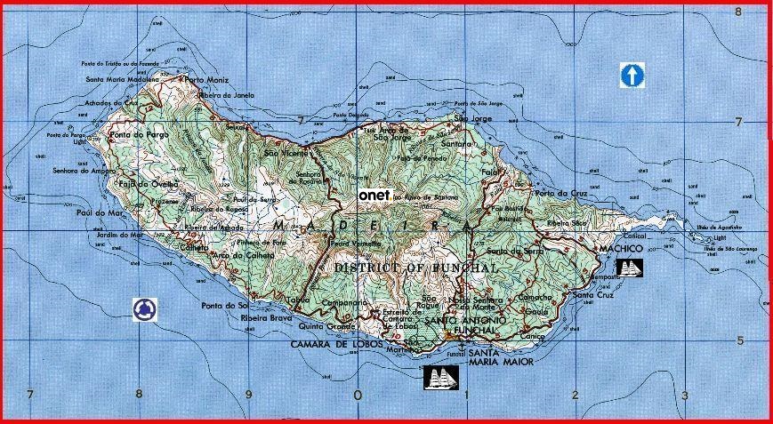
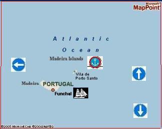
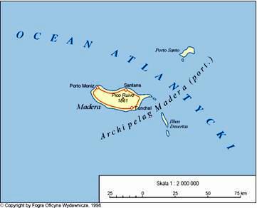
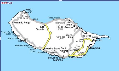
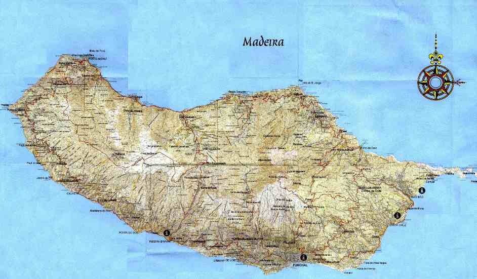
MADERA, Madeira, grupa wysp wulk. na O. Atlantyckim, na pn. od W. Kanaryjskich; stanowi region autonomiczny Portugalii; obejmuje wyspy: Madera (741 km2), Porto Santo (42,5 km2) oraz kilka nie zamieszkanych wysepek; łączna pow. 794 km 2, 253 tys. mieszk. (1991); powierzchnia górzysta (szczyt Pico Ruivo na wyspie Madera, 1861 m); region turyst. o świat. sławie, znany z łagodnego klimatu (średnia temperatura w styczniu ok. 16°C, w lipcu 22°C) i bogatej, podzwrotnikowej roślinności; uprawa winorośli, trzciny cukrowej, warzyw, drzew owocowych; hodowla bydła; rybołówstwo (połów tuńczyków, makreli); przemysł winiarski (słynne wina madera), hafciarstwo, wyroby z wikliny; gł. m. Funchal. Historia. W starożytności znana Fenicjanom, nie zamieszkana; w czasie wypraw 1418 i 1420 odkryta przez Portugalczyków, zasiedlona przez nich i zagospodarowana (najstarsze plantacje trzciny cukrowej w XV w.); 1580–1640 panowanie hiszp.; 1801 i 1807–14 pod zarządem bryt.; 1931 rebelia przeciw dyktaturze A.Ó. Carmony; od 1976 region autonomiczny.
FUNCHAL, m. w Portugalii, na pd. wybrzeżu wyspy Madera, ośr. adm. dystryktu F. Założone 1508. — 49 tys. mieszk. (1988); port handl. i rybacki; międzynar. port lotn.; słynne uzdrowisko klim. i kąpielisko; przemysł spoż., gł. winiarski.
WINIARSTWO, przetwórstwo owoców metodami domowymi, półprzem. oraz przem. na wino; także sztuka wytwarzania i pielęgnacji win. Winiarstwo obejmuje produkcję gł. win gronowych (co jest związane z uprawą winorośli), a także win owocowych oraz miodosytnictwo. W czasach starożytnych winiarstwo było już znane w krajach Bliskiego Wschodu, skąd rozpowszechniło się wraz z uprawą winorośli w krajach zach. i środk. Europy, a następnie na innych kontynentach. Wyjaśnienie istoty fermentacji podał 1863 L. Pasteur. Technologia winiarska rozwinęła się z tradycyjnych umiejętności wyrobu wina w poszczególnych rejonach uprawy winorośli; wino tam produkowane wykazuje charakterystyczne cechy lokalne (np. wino sherry, madera, portwein, tokaj). W Polsce wielowiekowe tradycje ma miodosytnictwo i pielęgnacja gronowych win importowanych; w okresie międzywojennym rozwinęła się produkcja win owocowych. Instytucją powołaną do regulowania w skali międzynar. ekonomicznych i techn. zagadnień uprawy winorośli i produkcji wina jest, zał. 1924, Międzynar. Biuro Winiarskie (Office International de la Vigne et du Vin, OIV) z siedzibą w Paryżu. Na pocz. lat 90. świat. produkcja wina gronowego wynosiła ok. 27 mld l, z czego więcej niż połowa przypadała na Europę (gł. Francja, Włochy, Hiszpania)
Madeira Islands
also called Funchal Islands, Portuguese Arquipélago Da Madeira,
Madeira Island, the largest of the group, is 34 miles (55 km) long and has a maximum width of 14 miles (22 km) and a coastline of about 90 miles (144 km) and rises in the centre to the Ruivo de Santana Peak (6,106 feet [1,861 m]). The greater part of the interior above 3,000 feet (900 m) is uninhabited and uncultivated; communities of scattered huts are usually built either at the mouths of ravines or upon slopes that descend from the mountains to the coast. Porto Santo Island is about 26 miles (42 km) northeast of Madeira; its main town, Vila de Porto Santo, is called locally the Vila. At each end of the island are hills, of which Facho Peak, the highest, reaches 1,696 feet (515 m). Crops include little besides wheat, grapes, and barley. The Desertas lie about 11 miles (18 km) southeast of Madeira and consist of three islets, Chão, Bugio, and Deserta Grande, along with the Prego do Mor off the north end of Chão Island. Rabbits and wild goats live on the poor pasture and attract occasional hunters to once-inhabited Deserta Grande. The Selvagens, or Salvage Islands, are three uninhabited rocks located 156 miles (251 km) south of Madeira, between the latter and the Canary Islands. The largest has a circumference of about 3 miles (5 km). It has been conjectured that the Phoenicians visited Madeira. The whole archipelago, however, was undoubtedly explored before the mid-14th century by Genoese adventurers, for an Italian map (the Laurentian portolano) dated 1351 depicts the Madeiras quite clearly. A Portuguese navigator, João Gonçalves Zarco, probably sighted Porto Santo in 1418, having been driven there by a storm when exploring the coast of western Africa. When Zarco visited Madeira in 1420, the islands were without human or land-mammal habitation, and his sponsor, Henry the Navigator, at once began their colonization. The dense forests were felled and burned (the fires are said to have raged for seven years), and much land was brought into cultivation. Grape cultivation was introduced from Cyprus or Crete by the Portuguese in the 15th century. Sugarcane is said to have been brought to Madeira from Sicily about 1452. Madeira is said to have been the location of the world's first sugarcane plantation, and the island's sugar trade quickly became important. Madeira wine, which is dark brown and ranges from dry to sweet with a hard aftertaste, became an important export in the 17th century. (The wine's modern producers agitate it artificially to reproduce the effects of shipment on stormy Atlantic voyages.) The sugar and wine industries of the Madeira Islands suffered temporarily when slavery was abolished in 1775 by the order of the Portuguese statesman-reformer the Marquês de Pombal.
The Madeira Islands' economy is still based on the production of sugar,
wine, and bananas. The common sweet potato and gourds of various kinds are
extensively grown, as is the kalo, or taro, introduced from the Pacific islands.
Most of the culinary vegetables of Europe are also grown on the islands in
plentiful quantities. In addition to common temperate fruits, oranges, lemons,
guavas, mangoes, loquats, custard apples, figs, pineapples, and bananas are
produced, the latter being an important export. Although agriculture
predominates in the Madeiran economy, handicrafts, tourism, and fishing are
notable subsidiaries. Handicrafts include woodworking and wickerworking.
Embroidery, which was introduced in 1850 by a Mrs. Phelps, an Englishwoman, now
employs thousands of women. Pop. (1987 est.) Madeira, 264,800; Porto
Santo, 4,700. Funchal city and capital of of the região autónoma (autonomous region) of the Madeira Islands in the North Atlantic. Funchal lies on the southern coast of Madeira Island. Founded in 1421 by the Portuguese navigator João Gonçalves Zarco, the city was briefly under Spanish (1580–1640) and British (1801, 1807–14) control. It is now the headquarters of Madeiran industry, commerce, and communications and is the site of a relay station in the Atlantic submarine cable system. The older part of the city focuses on the Sé cathedral (1485–1514) and has steep, narrow cobblestone streets. The buildings are generally whitewashed and are surrounded by gardens of tropical flowers; they line the curving shore of the Port of Funchal and spread inland on the lower slopes of an amphitheatre of mountains that reach 4,000 feet (1,200 m) in elevation. Stone walls support sloping terraces on which there is year-round cultivation.
Tourism, based on the scenery and the mild year-round climate, is a major
economic factor. Exports from Funchal include the famous Madeiran wines,
wickerwork, embroidery, fruit, fish, and dairy products. Economically
significant industries include sugar milling, cabinetmaking, and distilling.
Since 1960 Funchal's harbour and cargo-handling facilities have been enlarged
and modernized from time to time; it is now an important regional port of call
and bunkering facility. The city also has an international airport. Pop. (1981)
44,111. Copyright © 1994-2002 Encyclopædia Britannica, Inc. Canary (species Serinus canaria), popular cage bird of the family Carduelidae (order Passeriformes). It owes its coloration and sustained vocal powers to 400 years of selective breeding by humans. Varieties called rollers trill almost continuously, the notes running together; choppers have a loud trill of distinct notes. Well-known breeds include Hartz Mountain, Norwich, and Yorkshire. The average life span of a caged canary is 10–15 years; some have survived for more than 20 years. The canary is native to the Canary, Azores, and Madeira islands. The wild form is streak-backed and mostly greenish brown. Among other members of the genus are the serin of Europe and the brimstone canary, or bully seedeater (S. sulphuratus) of Africa, which is also kept as a pet. For the wild canary in the United States, see goldfinch; woodwarbler. For the wild canary in Australia, see warbler. For information on the black-throated canary, see seedeater. |