|
Bay of Biscay Encyklopedia Britannica (na tej stronie) PWN (na tej stronie)
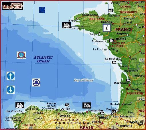
Bay of Biscay
Spanish Golfo De Vizcaya, French
Golfe De Gascogne,
The continental shelf is up to about 100 miles (160 km) wide off the coast of Brittany but narrows to less than 40 miles (65 km) off the Spanish shore. The edge of the shelf and the continental slope are dissected by numerous submarine canyons of which that of Cape Breton, in the southeastern corner of the bay, is one of the largest. Beyond the continental slope lies the Biscay Abyssal Plain, with depths of about 15,000 feet (4,550 m), which occupies about half the area of the bay. Much of it has a very flat topography. The surface currents of the Bay of Biscay are influenced by the clockwise circulation in the North Atlantic that produces a clockwise circulation in the bay. The range of mean spring tides is about 20 feet (6 m) on the French coast at the northern end of the bay near Ouessant Island, decreasing southward to about 12 feet (3.5 m) in the southeastern angle near Biarritz. The Bay of Biscay is noted among sailors for its rough seas. Gales can be severe and may exceed 70 miles (113 km) per hour. Squalls are also a hazard to navigation and may occur at any time of year. The climate on shore is maritime, with mild winters and cool summers.
The principal ports along the Bay of Biscay are
Brest, Nantes, La Rochelle, Bordeaux, and Bayonne in France, and Bilbao,
Santander, Gijón, and Avilés in Spain; none is able to take large vessels.
Resorts include La Baule, Biarritz, and Saint-Jean-de-Luz, all on the French
coast. Fishing is a principal industry. Oyster culture is practiced in shallow
lagoons and estuaries along the French coast. Copyright © 1994-2002 Encyclopædia Britannica, Inc.
BISKAJSKA, ZATOKA, fr. Golfe de Gascogne, hiszp. Golfo de Vizcaya, otwarta zatoka O. Atlantyckiego, między wybrzeżem Francji a Płw. Iberyjskim; pow. 194 tys. km2; średnia głęb. 1725 m, maks. — 5203 m (Basen Zachodnioeur.); w stromym stoku kontynentalnym podmor. kaniony; temp. wód powierzchniowych od 10–12°C w lutym do 17–20°C w sierpniu, zasolenie — 32–35‰; pływy do 6,7 m, u wybrzeży fr.; akwen częstych i silnych sztormów; do Z.B. uchodzą rzeki Loara, Garonna; rybołówstwo (sardynki, sardele, tuńczyki); hodowla ostryg; gł. porty: Brest, Bordeaux, San Sebastián, Bilbao |
|||||