|
Fernando de Noronha
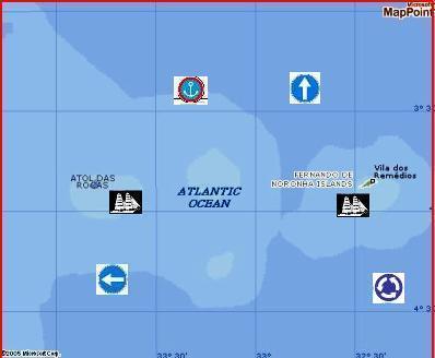
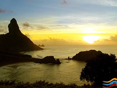
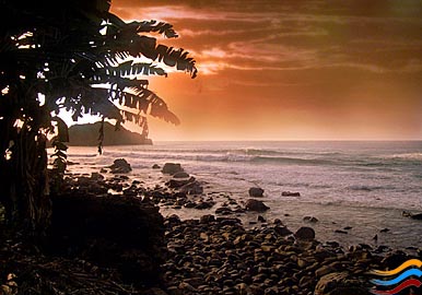
Information About Fernando de Noronha With crystalline waters and an exuberance of corals, dolphins, lobsters and colorful tropical fish, as well as wonderfully preserved beaches and virtually no pollution, Fernando de Noronha is a paradise for divers, surfers and all nature lovers. This beautiful and peaceful island is part of a volcanic archipelago of 21 islands which lie 345km off the northeast coast of Brazil. For years, a military outpost off-limits to visitors, this unspoiled island was declared a Marine National Park in 1988 and is now protected by IBAMA (the Brazilian Institute for the Environment). To preserve the unspoiled environment, only 420 tourists are allowed on the island at any one time, guaranteeing empty beaches and tranquility for the visitor at all times, as well as the opportunity to commune with nature. The islands were discovered in 1503 by the Portuguese explorer Amérigo Vespucci and were for a time a pirate lair. In 1738 the Portuguese built the Forte dos Remédios, later used as a prison in this century, and a church to strengthen their claim to the islands. A few scattered remains of the early fortifications still exist. Apart from the thousands of migratory birds that stop off at the island on their way south, the waters surrounding the island are filled with hundreds of playful dolphins, turtles, multi-colored fish, corals, sponges and other marine plants. It is no wonder, therefore, that Fernando de Noronha is the best place for scuba diving and snorkelling in Brazil. As well as excellent underwater activities, Fernando de Noronha is also the mecca for Brazilian surfers who come to ride the 2 meter waves (sometimes reaching as high as 5 meters) on the sandy beaches facing Brazil´s Atlantic coast. The best surf beaches are Cacimba do Padre, Bode, Boldró, Conceiçăo, and Meio. Riding, mountain biking and walking to some of the remoter beaches are also popular. There are interesting natural rock sculptures at the Baía dos Porcos beach, a waterfall at Praia do Sancho during the rainy season and a heavenly natural swimming pool among the rocks at Praia do Atalaia. The Morro do Pico is the highest point on the island at 321 meters (1,053 ft) and offers a splendid view of the archipelago, especially at sunset. The island has warm and pleasant temperatures of around 26°C (79°C )all year round, with a refreshing rainy season from February to July. The best time for diving is from April to November, when the waters are crystal clear and the surfing season runs from December to March. If you would like further information please click on the links below:
HISTORY OF THE ARCHIPELAGO
Navigational Chart Printed in Paris -1852 Many controversies surround the discovery of Fernando de Noronha. The map of the area sent in November, 1502 to Ercole d'Este, Duke of Ferrara, shows the archipelago as the "Ilha da Quaresma" (Isle of Lent).. From this it was supposed that knowledge of the existence of the island dated from the expeditions which passed near them during Lent in 1500, 1501, or 1502. The Viscount of Santarem attributed the discovery to Gaspar de Lemos, the captain of the supply ship in Cabral's fleet, sent back to Portugal in 1500 with the news of the discovery of Santa Cruz (Brazil). However, Gaspar's ship did not pass through the area of Fernando de Noronha during Lent; rather, after sailing the coast of Brazil and cutting brazilwood, Gaspar could have sighted the archipelago on June 24, the day of the festival of St. John, whose name he could have given to the island.
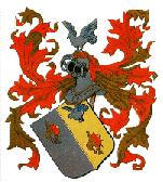
Coat of Arms of Fernao de Loronha (15th-16th cent.) Duarte Leite, after lengthy research, attributed the discovery of the island to the 1501-1502 expedition, whose command mistakenly attributed ownership of the island to Fernao de Loronha. Portuguese historian Jaime Cortesao infers there must have been another expedition to Brazil in 1502-1503, an expedition unknown except for a few clear remains. This would explain the questions as to the mention of the island on maps of the period. This expedition would have been under the command of Fernao de Loronha, who, by this account, personally began the taming of the land he received as payment for the Brazilwood he brought back from Brazil. It is in the course of this voyage that, according to Duarte Leite, Fernao de Loronha he would have discovered the archipelago named for him. Differing opinions aside, what is certain is that the first to describe the island was Americo Vespucci, who travelled in the expedition of Goncalo Coelho in 1502-1503. By the Decree of February 16, 1504, Dom Manuel I granted Fernao de Loronha the archipelago, making this the first hereditary land grant in Brazil. This system of land grants was later inaugurated on the mainland of Brazil between 1534-1536, when Dom Joao III established no less than 14 such grants along the coast in favor of twelve grantees. The descendants of Loronha continued to receive title to possession of the island by royal decree until his great-great-grandson, Joao Pereira Pestana in 1692. In 1534, the Fernando de Noronha Archipelago was invaded by the English, and from 1556 until 1612, it was held by the French. In 1612, Claudio de Abbeville, a Capuchin missionary, landed on the island and found one Portuguese and seventeen indian men and women who had been banished from mainland Pernambuco.
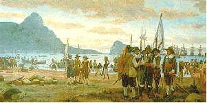
Retaking of the Island - Oil by Wash Rodrigues In 1628, Noronha was invaded by the Dutch, who were displaced two years later by the expedition commanded by Rui Calaza Borges according to the January 14, 1630 order of Mathias de Albuquerque. In 1635, the Dutch, under the command of Admiral Cornelis Cornelizoon Jol, attacked the island again and occupied it for nineteen years. During this period, the island was used by the Dutch as a site for a treatment and convalescence base for its troops, a third of whom in Pernambuco suffered from diseases such as scurvy and dysentery. The Island became known as Pavonia, in honor of Michiel de Pauw, one of the directors of the Dutch West Indies Company. In 1646, the Dutchbuilt a small fort on the high ground at the site of the later Forte de Nossa Senhora dos Remedios (Fort of Our Lady of Medicines). The Royal Writ of September 7, 1696 ordered the island occupied and garrisoned and the best sites selected for fortification to avoid the constant invasions. However, this order was not obeyed and the Atlantic territory continued at the mercy of invaders. On September 24, 1700, by order of a Royal Writ, the Capitania of Fernando de Noronha reverted to the crown and became part of the Capitania of Pernambuco. Finding it uninhabited and completely abandoned in 1736, the French East Indies Company took the island and renamed it Isle Dauphine. In 1737, at the order of Governor Henrique Luis Pereira Freire, 250 police led by Lt. Col. Joao Lobo de Lacerda decisively occupied the island without resistance. To frustrate further attacks by the French, the forts of Nossa Senhora dos Remedios, Nossa Senhora de Conceicao and Santo Antonio were constructed. The church of N. S. dos Remedios, a landmark of the repopulation of the island, was completed in 1772. About this time, the first prisoners were sent to the island. Initially, prisoners were sent only occasionally, but this development prompted preventive measures which profoundly altered the island environment. Vegetative cover was destroyed and trees were felled to prevent escapes and to eliminate hiding places for inmates; and, non-native species were introduced to the island. Consequences of these changes remain visible today. In1739, the forts of Sao Joao Batista dos Dois Irmaos and Sao Joaquim do Sueste. By the Royal Writ of August 16, 1755, Angola came to contribute the annual sum of $4,000,000 to cover the expenses of the fort of Fernando de Noronha, a subsidy which continued until the eve of the proclamation of the independence of Brasil. In 1789, the Portuguese government planned to install an agricultural colony on the island, hoping to make it less dependent on the royal treasury. But this idea was not accepted by the then-governor of Pernambuco, Dom Thomas Jose de Melo. In 1837, on the occasion of Pernambuco's republican revolution, the provisional government directed Capt. Jose de Barros Falcao de Lacerda to demolish the fortifications of the island and to return its prisoners to the mainland. In 1822, Col. Luis de Moura Accioli assumed command of Fernando de Noronha and the island continued as a part of Pernambuco, its internal affairs administered by Pernambuco's Ministry of War. In 1865, regulations governing the island were promulgated and in 1877, the administration and custody of the island was transferred to the Ministry of Justice. In 1865, Emperor Pedro II signed new orders governing the island. After the proclamation of the Republic, Baron de Lucena was offered the Ministry of Justice, but demanded as a condition of his acceptance of the post that Fernando de Noronha be returned to thecontrol of Pernambuco. Thus, the island was returned to Pernambuco by Decree 1.371 of November 14, 1891.
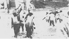
Prisoners carrying embarking visitors in sedan chairs - 1939 In 1897, the government of Pernambuco took control of the penitentiary at Fernando de Noronha and converted it to use as a state prison. It remained under under state control until 1938, when Brazil's federal Ministry of Justice paid CR$ 2,000,000. for it and converted the island to use as a political prison and penal colony.
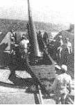
German Zepellin over the island - 1933 At the beginning of the 20th century, the English arrived to provide technical cooperation in telegraphy (The South American Company). Later the French came with the French cable and the Italians with Intalcable. In 1942, during World War II, the archipelago was made a Federal Territory, and political and ordinary prisoners were sent to the prison
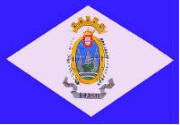
Federal Territory of Fernando de Noronha flag In 1943, a new federal decree called for administration of the archipelago, which had been in the Ministry of War, by a Governor of the Federal Territory of Fernando de Noronha. On August 23, 1943, Col. Tristao de Alencar Araripe became the first governor of the new Federal Territory. Noronha was administered by the Brazilian army until 1981, by the Brazilian air force until 1986 and by the High Command of the Armed Forces until 1987. Most of the infrastructure on the island, including the airport, roads, schools, and hospital, date from this period of military administration. Agreements between Brazil and the United States allowed for the stationing of Americans on the archipelago from 1942 to 1945 (the Second World War) and from 1957 to 1962 (satellite tracking station operated by the U. S. National Aeronautics and Space Administration).
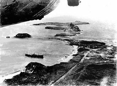
Heavy gun installed in 1942 between dos Porcos Bay and Sancho Bay In 1987, the Federal Territory entered into a period of civilian administration by the Ministry of the Interior. This period, the only civilian administration in the history of the Federal Territory, lasted until 1988, when the new Constitution of Brazil reannexed the archipelago to the State of Pernambuco. Now, it is administered as a State District by a General Administrator appointed by the governor of Pernambuco and approved by its state legislature. Today, Fernando de Noronha survives on tourism, restricted by the limitations of its delicate ecosystem, and traditional fishing, the catch being returned to the island for local consumption. In addition to the historical interest noted above, the archipelago has been the subject of the attention of various scientists dedicated to the study of its flora, fauna, geology, etc. One of the earliest works was published over 100 years ago by Pocock (1890). Later works have been published by Bjornberg (1954), Lopes e Alvarenga (1955), Almeida (1958), and Paiva (1967), among others. In December, 1995, the constitution of the archipelago was promulgated, and in March, 1996, the first election was held for the District Council, a representative forum which is the local government for the archipelago. |
||||||||||